GIS: Myth vs Reality
How much of what you believe about GIS is actually true?
A Geographic Information System (GIS) combines maps with data. It allows you not only to see where things are located, but also to gain a deep understanding of their spatial relationships and patterns, enabling you to make decisions based on real data.
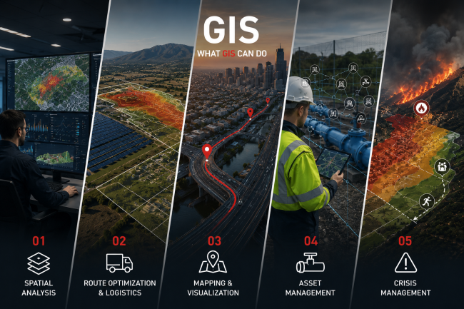
The 5 Most Important Things a GIS Can Do
- Spatial Analysis
❌ MYTH
A GIS is simply a digital map.
✔ REALITY
It combines different geospatial data—such as land use, elevation, and road networks—to answer complex questions. For example, it can identify the most suitable location for a solar farm or pinpoint areas with an increased risk of flooding.
- Route Optimization / Logistics
❌ MYTH
GIS only shows where something is located.
✔ REALITY
A GIS system analyzes the road network, traffic, and other parameters to calculate the fastest or most cost-effective route. This capability is utilized daily by distribution and transportation companies, as well as navigation apps.
- Mapping & Visualization
❌ MYTH
Maps are just images.
✔ REALITY
It helps users transform complex data into understandable digital maps, charts, and 3D visualizations, facilitating the understanding of spatial patterns and decision-making. Maps can be interactive, dynamic, and display data in real time and/or in 3D.
- Asset Management
❌ MYTH
GIS is used only by “experts.”
✔ REALITY
It is used daily by ordinary users to manage water, electricity, and telecommunications networks, as well as all types of infrastructure.
- Crisis Management
❌ MYTH
GIS is only useful after a natural disaster.
✔ REALITY
It helps with risk prediction, planning, and prevention before a problem occurs. It supports risk assessment and the planning of response measures for natural disasters and emergencies, such as floods, wildfires, and earthquakes, enhancing the speed and effectiveness of the response.