
Projects
Explore our portfolio of success stories across a diverse range of geospatial services.
Explore our portfolio of success stories across a diverse range of geospatial services.
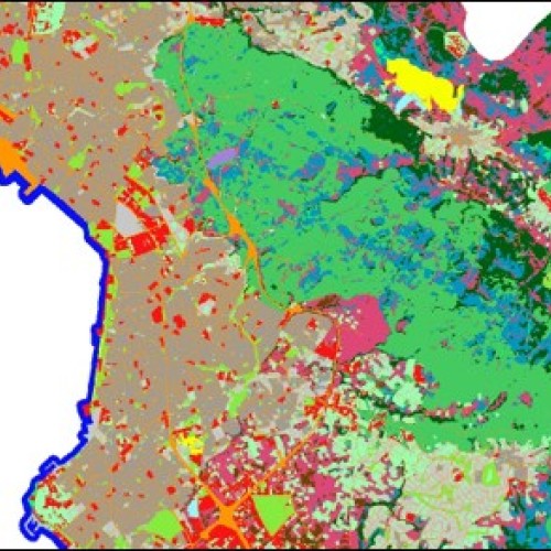


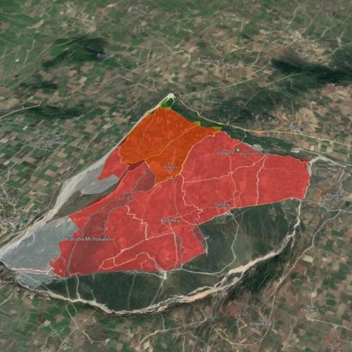
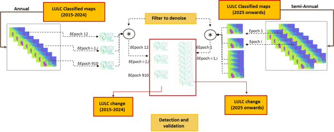
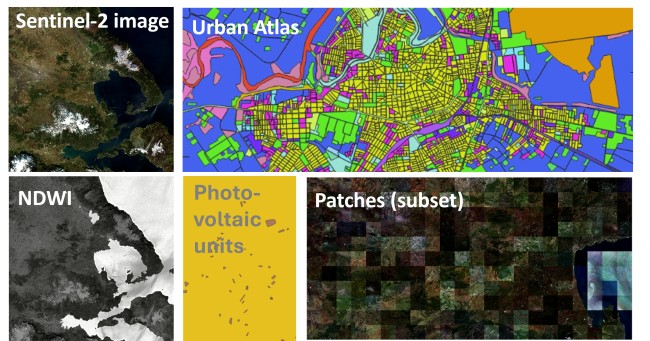
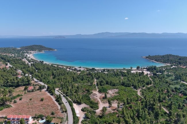
Consortis Geospatial is a key contributor to the Sat4GAIA national satellite space project – Axis 3: Land Monitoring Services. The project aims to boost Greece's capabilities in satellite technologies and promote the exchange and utilization of geospatial data within the Copernicus and GEOSS (Global Earth Observation System of Systems) frameworks.
Funded entirely by the European Union through the Recovery and Resilience Facility (RRF), Sat4GAIA develops and deploys small satellites with multipurpose payloads to meet both national and European observation needs.
The Challenge
Lack of systematic and real-time satellite monitoring impairs Greece’s ability to sustainably manage land resources, respond to disasters, and support data-driven policy making. Without accurate and timely data, government agencies face difficulties in protecting ecosystems, optimizing agriculture, and ensuring public safety.
The Solution
Consortis delivers high-end geospatial services powered by satellite data to monitor, classify, and analyze land surface dynamics:
Benefits
Consortis’ contributions to Sat4GAIA enhance:
EUROPEAN SPACE AGENCY
EUROPEAN SPACE AGENCY
Co-Protect: Collaborative Formation of Interoperable and Holistic Civil Protection Systems
Consortis Geospatial actively participates in CO-PROTECT, an innovative collaborative initiative bringing together government agencies, civil protection organizations, critical infrastructure maintenance bodies, and leading Greek technology companies. Co-funded by the European Regional Development Fund (ERDF) and national resources under the Operational Program Competitiveness, Entrepreneurship & Innovation (EPAnEK), the project aims to enhance disaster management capabilities in Greece.
The Problem
Climate change has intensified the frequency and severity of natural phenomena, such as floods, droughts, heatwaves, earthquakes, and wildfires. Existing civil protection systems and critical infrastructure face significant challenges, requiring more comprehensive and technologically advanced solutions to effectively address these risks.
The Solution
CO-PROTECT focuses on the development and enhancement of products and services for disaster management, targeting four key areas:
Contributions by Consortis Geospatial
Benefits
CO-PROTECT delivers multidimensional benefits for disaster management:
CO-PROTECT empowers Greece to confront natural disasters with advanced technological solutions, safeguarding society, the environment, and the nation’s critical infrastructure.
Ministry of Development and Investments
19 Organizations (public and private)
Greece


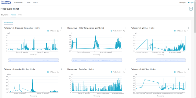
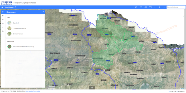
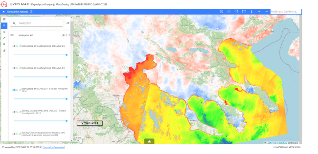
FLOODGUARD, Greece. Cross-Border Flood Management - Evrymap.
The Floodguard Project, funded by the INTERREG VA Greece-Bulgaria 2014-2020 program, aims to strengthen collaboration between Greece and Bulgaria in managing flood risks in the cross-border river basins of the Evros, Nestos, and Strymonas rivers. This initiative focuses on developing a comprehensive action plan for flood prevention and response by leveraging advanced geospatial technologies and data analysis.
The Problem
The cross-border river basins of the Evros, Nestos, and Strymonas face increased flood risks due to climate change and the lack of integrated water monitoring and management systems. The absence of coordinated cooperation between Greece and Bulgaria complicates decision-making and delays flood prevention and mitigation efforts, putting local communities and economies at risk.
The Solution
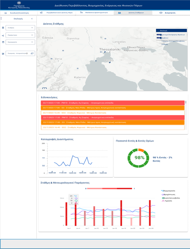
The Floodguard Project addresses these challenges by implementing an advanced cross-border flood risk management system, centered around the EVRYMAP Web GIS platform, developed by Consortis Geospatial.
EVRYMAP Web GIS Platform
EVRYMAP is a cutting-edge web GIS platform designed to store, manage, and visualize data from telemetric water monitoring stations. These stations collect real-time data on water levels, temperature, pH, depth, and other critical indicators, feeding them into the platform for analysis and visualization.
Key Features of EVRYMAP
Dashboard and Data Visualization
The platform’s dashboard, connected to an Apache Superset database, provides:
Benefits of the Floodguard Project
By integrating these features, the Floodguard Project delivers:
The Floodguard Project, through the EVRYMAP platform, establishes a modern, proactive, and technology-supported approach to flood risk management, enhancing the resilience of cross-border regions.
Decentralized Administration Macedonia – Thrace
Eastern Macedonia and Thrace


An effective, flexible, and responsive team that offered solutions and stelar expertise.
An effective, flexible, and responsive team that offered solutions and stelar expertise.
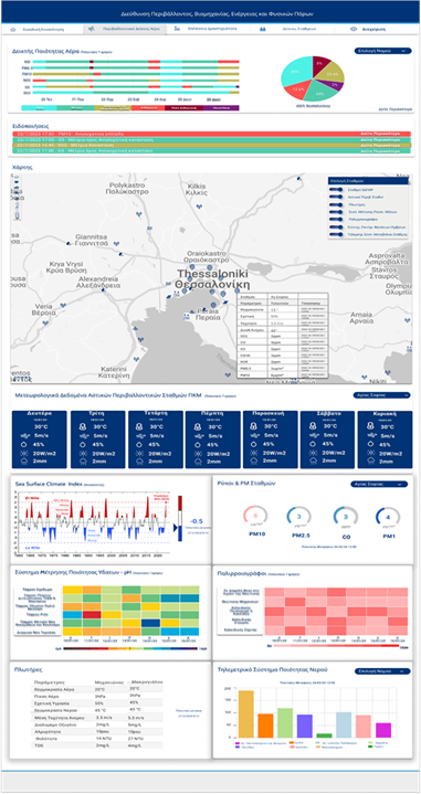
Interoperable Geoinformation System for the General Directorate of Development and Environment of the Region of Central Macedonia
Consortis Geospatial, in collaboration with Consortis and Draxis, is implementing Phase 1 of the project “Interoperable Geoinformation System for the General Directorate of Development and Environment of the Region of Central Macedonia.”
This project is part of the “Antonis Tritsis” program under Priority Axis “Digital Convergence.” Its goal is to develop a comprehensive interoperable geoinformation system to centralize, manage, and disseminate geospatial and descriptive data, enhancing the functionality of the Region and enabling integration with other Directorates.
The Problem
The Region of Central Macedonia manages a wealth of geospatial data through disparate systems and processes. This fragmented approach leads to operational challenges, limited interoperability, and reduced efficiency in service delivery.
The Solution
The project involves the design, development, and pilot operation of an interoperable geoinformation system that:
Subsystems
The solution includes the development of two main subsystems:
1. Development and Environment Subsystem
Covers the Regional Units (R.U.) of Thessaloniki, Imathia, Kilkis, Pella, Pieria, Serres, and Halkidiki:
2. Environment, Industry, Energy, and Natural Resources Subsystem
Includes:
EVRYMAP Application
The proposed solution features EVRYMAP, Consortis Geospatial’s advanced geoinformation platform, which:
EVRYMAP will be configured and expanded to provide access to Subsystem 1 and the mapping platform (Web GIS Portal), as well as to Subsystem 2, including the Dashboard, the Open Governance System, and the Digital Monitoring System for Climate Change Adaptation (PESPKA).
Benefits
The project will deliver:
Region of Central Macedonia
Central Macedonia


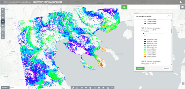
Prevention and Management of Coastal Erosion Risks Through and advanced Observatory System
Consortis Geospatial, on behalf of the Region of Central Macedonia (RCM), developed an innovative Observatory System for mapping, forecasting, and managing coastal zone erosion. The project is part of the Priority Axis "Promoting Climate Change Adaptation, Risk Prevention, and Management" under the Operational Program "Central Macedonia."
The Problem
Coastal zone erosion poses a significant threat to the sustainability and development of the RCM. Natural causes and human activities, combined with the effects of climate change, exacerbate the risk, while the absence of systematic data collection and analysis made it challenging to prevent and address the phenomenon effectively.
The Solution
Consortis Geospatial developed a digital observation hub that includes:
Benefits
The Observatory offers multiple advantages:
The Coastal Zone Erosion Observatory is a powerful tool for erosion risk prevention, management, and mitigation. By applying innovative technologies, Consortis Geospatial ensures environmental protection while fostering sustainable development and resilience in the coastal areas of the Region of Central Macedonia.
Region of Central Macedonia (RCM)
Central Macedonia

Development of an Integrated Geospatial System for the Road Network of the Kilkis Regional Unit – MOBIROAD
In 2019, Consortis Geospatial completed the development of a geospatial system for recording and managing road network damages for the Kilkis Regional Unit. This project marked a significant step toward modernizing road network management by automating processes and enhancing the efficiency of the responsible services.
The Problem
The management of the Kilkis road network relied on traditional, non-automated methods, making the process time-consuming and prone to errors. The lack of standardized procedures for recording and repairing damages caused delays in planning and executing tasks, reducing the overall efficiency of services.
The Solution
Consortis Geospatial developed an integrated geospatial system with a Road Network Damage Recording Subsystem, which included:
Benefits
The geospatial system provides significant advantages for road network management:
Consortis Geospatial’s project laid the foundation for a modern, efficient, and transparent management system for the Kilkis Regional Unit’s road network, promoting sustainability and transportation safety in the region.
Region of Central Macedonia through the Sub-Directorate of Technical Works of the Kilkis Regional Unit
Kilkis Regional Unit, Greece


Development of a Database and Construction Information Application for the Municipality of Pavlos Melas
Consortis Geospatial undertook the development of a comprehensive database and construction information application for the Municipality of Pavlos Melas. The project aims to modernize the management of building permits and improve the provision of services to citizens and professionals.
The Problem
The management of building permits in the Municipality of Pavlos Melas relied on an analog archive, making the process fragile, time-consuming, and prone to wear and tear from frequent use. The absence of a digital system hindered the swift handling of requests, while management processes remained inefficient.
The Solution
Consortis Geospatial developed a modern Geographic Information System (GIS) that includes the following features:
Benefits
The project delivers significant advantages for building permit management and service improvement in the municipality:
The new system represents a major step forward in improving construction management and service delivery, positioning the Municipality of Pavlos Melas as a pioneer in utilizing modern technologies to better serve its citizens.
Municipality of Pavlos Melas
OTS
Municipality of Pavlos Melas

Geospatial Information System Service & Road Network Damage Recording Platform – Municipality of Mykonos
As part of the digital transformation of the Municipality of Mykonos, the Geospatial Information System Service for Infrastructure Recording and Road Network Damage Recording Platform was implemented. The project involved detailed mapping of road network elements using mobile mapping technology and the development of an advanced digital tool for real-time damage recording and management.
The Problem
The Municipality of Mykonos faced significant challenges in managing its road network, as the lack of systematic recording of fixed assets and damages led to:
The Solution
Using modern geospatial technologies and the Imajbox 3TX+ mobile mapping system, a detailed mapping of 270 kilometers of the road network was conducted, collecting 180,000 images and extracting critical elements, such as:
The data was managed through the Imajview software, while image anonymization was applied using Gallio Pro anonymization to ensure data privacy.
Additionally, the MOBIROAD application was integrated, expanded, and optimized, allowing municipal employees to record, manage, and resolve road network issues in real-time.
The Benefits
Municipality of Mykonos
MYKONOS

Development of the ReuseApp Application and Online Platform for Material Reuse
Consortis Geospatial, in collaboration with DIADYMA S.A., developed an innovative online platform and the DIADYMA ReuseApp application. The initiative aims to promote material reuse and reduce environmental impact. The platform and app enable citizens to deliver or collect reusable materials from Material Reuse Centers (MRCs), fostering a more sustainable lifestyle.
Limited public awareness and restricted access to information about material reuse result in increased waste levels, further burdening the environment. Material Reuse Centers required a modern platform to facilitate interaction with citizens, making the processes of delivering and receiving materials more efficient.
Consortis Geospatial designed and implemented a comprehensive solution comprising:
The online platform and DIADYMA ReuseApp serve as exemplary tools promoting sustainability and encouraging citizen contributions to waste management.
Visit the platform: https://reuse.diadyma.gr
Download the app: DIADYMA ReuseApp
DIADYMA S.A.


Consortis Geospatial has undertaken a project for upgrading the Real Estate Management System of the Municipality of Volvi, updating the existing database, and providing technical support to municipal staff
The Problem
The Municipality of Volvi manages a significant number of properties, recorded across different systems and files, creating challenges in administration. The lack of an integrated and updated system results in:
The Solution
The project includes
Upgrading the existing Real Estate Management System using Web GIS technologies to improve functionality and data accessibility
Updating and aligning municipal property data with the National Cadastre to ensure compatibility and data reliability
Providing technical support and training to municipal staff, ensuring efficient use of the upgraded system
Subsystems
Property Management Subsystem
Technical Support & Training Subsystem
Project Benefits
MUNICIPALITY OF VOLVI
MUNICIPALITY OF VOLVI


The 1rst Digital Traffic Accident Record System - Development of a Road-Intersection Accident Registry with Spatial Visualization
As part of the project "Assignment of Technical Advisor Duties", under paragraph 2 of Article 128 of Law 4412/2016, Consortis Geospatial supported the Directorate of Fixed Track Infrastructure, Maintenance, and Safety (D14) in developing a modern Road-Intersection Accident Registry. The project involved data migration to a new geoinformation system based on QGIS, with the potential for future upgrading to a fully web-based application.
The Problem
The lack of spatial data in the existing road network, combined with the use of outdated accident data management systems, hindered effective monitoring and analysis of road traffic accidents. The previous system relied on text-based forms, making accurate data entry and spatially oriented analysis challenging.
The Solution
Consortis Geospatial implemented a comprehensive system upgrade through the following steps:
Benefits
The new system provides multiple advantages for managing and analyzing road accident data:
The new Road-Intersection Accident Registry serves as a modern management tool supporting D14’s strategic objectives, advancing road safety and the efficient management of the road network.
Ministry of Development and Investments


A new contract has been signed with the Municipality of Thermaikos for the upgrade of the Geospatial Data Distribution System, including the expansion of existing functionalities and the improvement of its performance.
The Problem
The Municipality of Thermaikos manages a significant amount of geospatial information, which serves the needs of municipal services and citizens. However, the existing system faces challenges related to:
The Solution
The project includes:
Subsystems
Project Benefits
MUNICIPALITY OF THERMAIKOS
MUNICIPALITY OF THERMAIKOS


Gi-NeXt: Next Generation Creative and Entertainment Technology Platforms (GI-Cluster)
Consortis Geospatial is participating in the Gi-NeXt collaborative project, which brings together 11 Greek companies aiming to develop innovative, advanced products and services with high added value. The project is implemented under the 2014-2020 NSRF Action "Collaborative Innovation Clusters" of the General Secretariat for Research and Innovation, co-funded by national and EU resources through the European Regional Development Fund (ERDF).
The Problem
The creative and entertainment technology industry demands continuous innovation to meet modern market needs, including the development of advanced games, communication platforms, and data processing tools. However, the lack of integrated tools and technologies limits companies' ability to produce high-added-value products.
The Solution
Gi-NeXt focuses on three main collaborative actions:
Consortis Geospatial's Contribution
Consortis Geospatial contributes to the project by developing an innovative artificial intelligence model for online and mobile games. Key activities include:
Benefits
The Gi-NeXt project provides multiple benefits:
Gi-NeXt represents a strategic collaboration, leveraging advanced technology to position Greek companies as leaders in creative and entertainment technology innovation.
Υπουργείο Ανάπτυξης και Επενδύσεων
Greece

A new contract has been signed with the Municipality of Kassandra for providing support and enhancement services for the Municipal Property Management System, including database updates and technical assistance to ensure seamless system operation
The Problem
The Municipality of Kassandra owns a large portfolio of properties, managed through outdated procedures, leading to
The Solution
The project includes
Subsystems
Municipal Property Management Subsystem
Technical Support & Training Subsystem
Project Benefits
MUNICIPALITY OF KASSANDRA
MUNICIPALITY OF KASSANDRA
RECREATE – smaRt ECosystem foR improvEment of public Transport pErformance
Consortis Geospatial has developed the innovative i-Recreate application, aimed at revolutionizing the bus commuting experience by making it more convenient and engaging. The application enables users to track the real-time location of buses, stops, and bus occupancy levels, introducing a new era for public transportation.
The i-Recreate app was developed as part of the RECREATE research project, funded by the Innovation Investment Plans of the Region of Central Macedonia and implemented by Consortis Geospatial, the Transport Engineering Laboratory of Aristotle University of Thessaloniki (AUTh), KTEL Thessaloniki S.A., and other collaborating entities.
The Problem
Public transportation passengers often face a lack of real-time information about bus arrivals, locations, and occupancy levels, leading to uncertainty and delays in planning their trips. At the same time, transit authorities struggle to optimize their strategic planning due to the unavailability of accurate real-time data.
The Solution
The RECREATE project focuses on developing an innovative ecosystem of applications, with the i-Recreate app as its core tool. This app:
Tracks buses and occupancy levels in real-time: Leveraging technologies like Automatic Passenger Counting (APC) and Automatic Vehicle Location (AVL), it provides precise information for bus route 83 (Thessaloniki - Lagadas).
Delivers a user-friendly experience: Available on Android and iOS, it allows users to access it effortlessly via the Play Store and App Store.
Supports strategic planning: Transit authorities can use the app's data to improve route management and enhance efficiency.
Benefits
i-Recreate, as part of the RECREATE project, lays the foundation for a new, smart ecosystem for public transportation, enhancing citizens' quality of life and the efficiency of transit systems. Download the app and experience the new reality in public transport!
Region of Central Macedonia - Managing Authority of Central Macedonia
Thessaloniki Prefecture


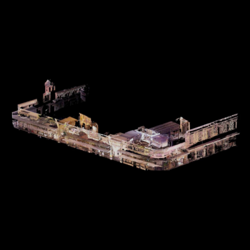
Survey and Architectural Documentation of the "Ktiriaches Ypodomes S.A." Building Complex in Agios Minas, Thessaloniki
In 2020, Consortis undertook the survey and architectural documentation of the building complex owned by "Ktiriaches Ypodomes S.A." in the historic center of Thessaloniki, near the Church of Agios Minas. The project focused on two heritage buildings that are an integral part of the urban fabric and cultural identity of the city.
The Problem
Constructed in the 1930s, the two buildings possess significant architectural value and required detailed documentation for their preservation and future utilization. The complexity of the structures, their historic character, and the need for precision in measurements made this project technically demanding.
The Solution
Consortis implemented a comprehensive approach combining advanced technologies and traditional methods:
Benefits
The documentation of the building complex by Consortis provided numerous benefits:
This project highlights Consortis’ commitment to protecting and promoting cultural heritage, using technology to bridge the past and the future.
Ktiriaches Ypodomes S.A.
Consortis Architects
Agios Minas, Thessaloniki

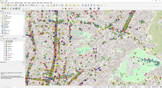
Implementation of an OpenStreetMap–PostgreSQL Data Synchronization Mechanism to Strengthen the Geospatial Infrastructure of the Municipality of Athens
Consortis Geospatial, specializing in the delivery of advanced geospatial technology solutions and with extensive experience in digital infrastructure modernization projects, undertook and successfully completed the development of an OpenStreetMap (OSM) data synchronization mechanism integrated with a PostgreSQL/PostGIS database for the Municipality of Athens.
By leveraging open-source technologies and modern containerization practices, the project established a resilient, automated, and reliable geospatial data infrastructure.
The Challenge
The continuous evolution of geospatial data necessitates the systematic alignment of municipal geospatial databases with the latest updates from OpenStreetMap—a global, open mapping platform that provides freely accessible maps and geographic data to public authorities, businesses, and citizens worldwide. OSM supports critical applications such as routing, accessibility analysis, and spatial planning.
Given its operational scale and growing requirements, the Municipality of Athens required a system capable of automatically updating its PostGIS database at regular intervals, seamlessly integrating all OSM changes—whether new points of interest, modifications to the urban fabric, or updates to street nomenclature.
Additionally, the Municipality required targeted mapping of accessibility-related features, such as ramps and pedestrian crossings, to better serve all citizens, including vulnerable population groups.
In the absence of an automated synchronization mechanism, the Municipality faced delays, increased operational workload, and the risk of maintaining outdated or unreliable data.
The Solution
The solution was designed using Docker, PostgreSQL/PostGIS, and Kartoza Docker-OSM, with isolated Docker containers ensuring operational stability, security, and simplified maintenance.
The container-based architecture enables rapid deployment, streamlined upgrades, and effortless system recovery without complex reconfiguration procedures. Through automated synchronization, simplified maintenance processes, and real-time data availability, the Docker-OSM ecosystem establishes a robust foundation for future digital extensions and enhanced citizen-facing services.
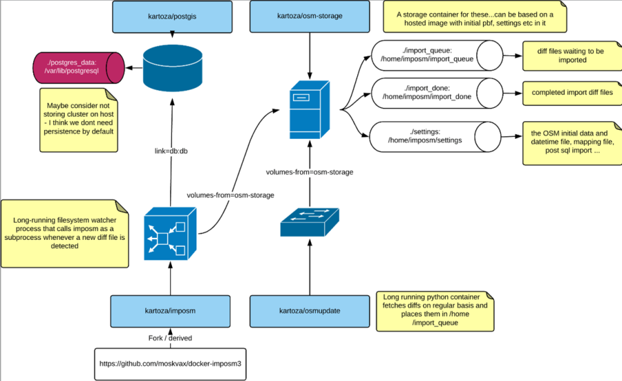
The infrastructure follows containerization principles and Infrastructure as Code (IaC), enabling rapid provisioning and efficient lifecycle management. Each subsystem operates independently within dedicated Docker containers, safeguarding overall system resilience and security.
Key operational features include:
This architecture ensures that the GIS backend remains streamlined, resource-efficient, and fully optimized to support applications and dashboards without manual intervention.
Full automation of the synchronization workflow enables near real-time integration of OSM updates into the PostGIS database, ensuring accurate, up-to-date geospatial information and uninterrupted operation of critical digital services.
Benefits
The project delivers multiple strategic and operational benefits:
The adoption of open-source software and automation strengthens public administration capabilities, enabling municipal services to monitor, analyze, and visualize urban developments without delay—thereby enhancing digital services and supporting data-driven urban planning.
Continuous access to updated geospatial data supports sustainable mobility initiatives and informed decision-making, particularly in matters of accessibility. Regular updates assist vulnerable groups—including persons with disabilities, elderly citizens, and parents with strollers—in identifying accessible routes and infrastructure such as ramps, restrooms, and pedestrian crossings, improving safety, autonomy, and overall quality of life.
The open-source stack (PostgreSQL/PostGIS, Imposm) ensures proven reliability and operational independence, eliminating reliance on external API calls and maintaining functionality even in cases of connectivity disruption.
The absence of licensing costs enhances long-term financial sustainability and ensures effective budget control during both implementation and operational phases.
Through the successful delivery of this project, Consortis Geospatial has laid the groundwork for smarter, more interconnected, and sustainable urban management. The initiative advances the Municipality of Athens’ transition toward digital governance, strengthening its technical infrastructure while delivering measurable value to citizens and businesses alike.
Municipality of Athens Development S.A. for Information Technology and Operational Units of Local Authorities
Municipality of Athens
Local Urban Plan of the Municipality of Rethymno
Consortis, as a member of the Association of Economic Operators, responsible for implementing the study, plays an active role in the development of the Local Urban Plan (LUP) for the municipal units of Lappaioi, Arkadi, Rethymno, and Nikiforos Fokas. Among other supporting tasks, Consortis is specifically responsible for delivering the study’s land surveying component—a critical step in the spatial and environmental planning of the region.
The Problem
The absence of modern urban planning in key rural and semi-urban areas of Rethymno has resulted in:
Consortis’ Solution
A fundamental requirement for delineating settlements lacking clear boundaries, their potential expansions, and broader areas designated for urban development (residential and productive) is the prior demarcation of nearby streams. To address this, Consortis’ Department of Cadastre and Land Surveying undertook a comprehensive and technically demanding surveying program that includes:
Scope of the Contract
The study is being carried out under a public contract signed between the Technical Chamber of Greece (TEE) and the Association of Economic Operators, with Consortis playing a pivotal role in its technical implementation.
Benefits of the Local Urban Plan
This project underscores Consortis’ ongoing commitment to providing technically robust spatial planning solutions that enhance both the built and natural environments, while fostering the social and economic prosperity of local communities.
TECHNICAL CHAMBER OF GREECE
DIKTYO S.A., CHRISTOS CHRISTIDIS
MUNICIPALITY OF RETHYMNO
Consortis’ Comprehensive Development Project at Xenia Paliouri
Consortis is implementing a technically advanced and multidimensional project at the site of Xenia Paliouri, Municipality of Kassandra, Chalkidiki, with the overarching goal of achieving complete topographic and legal readiness of the property to unlock its full development and investment potential.
Project Scope
Through its expert team of surveyors in the Topography and Cadastre Department, Consortis is undertaking a wide-ranging suite of topographic, technical, and legal services across a public land area of 322,572 acres (approximately 32,257 hectares) in Xenia Paliouri, located in the Municipality of Kassandra, Halkidiki.
The project includes:
All project activities are fully aligned with the provisions of Joint Ministerial Decision No. 17188 EX 2024 and the current Special Public Real Estate Area Development Plan in the Government Gazette. (ΕΣΧΑΔΑ)
The Challenge
Despite its considerable size, advantageous location, and strategic investment interest, the Xenia Paliouri, Municipality of Kassandra, site faces persistent development barriers, primarily due to:
These issues have significantly complicated efforts to mature the property for development, making investment planning both complex and high-risk.
Consortis’ Integrated Solution
To address these challenges, Consortis has designed and is delivering a comprehensive, structured implementation plan aimed at removing all technical and legal obstacles and ensuring full regulatory compliance:
Key Benefits
Consortis’ holistic approach provides a range of strategic advantages:
A Model of Technical Expertise and Strategic Execution
The Xenia Paliouri project exemplifies Consortis’ capability to successfully manage and deliver large-scale, high-complexity projects. Through precise technical execution, cross-disciplinary coordination, and a future-oriented vision, Consortis provides trustworthy, transformative solutions that create tangible value for development planning and investment readiness.
PREMIUM PROPERT DEVELOPMENT ΑΝΩΝΥΜΗ ΕΤΑΙΡΕΙΑ ΕΚΜΕΤΑΛΛΕΥΣΗΣ ΑΚΙΝΗΤΩΝ ΚΑΙ ΤΟΥΡΙΣΤΙΚΩΝ ΕΠΙΧΕΙΡΗΣΕΩΝ
ASSIGNING AUTHORITY: PREMIUM PROPERTY DEVELOPMENT S.A. – REAL ESTATE AND TOURISM ENTERPRISES MANAGEMENT COMPANY
XENIA PALIOURI, MUNICIPALITY OF KASSANDRA

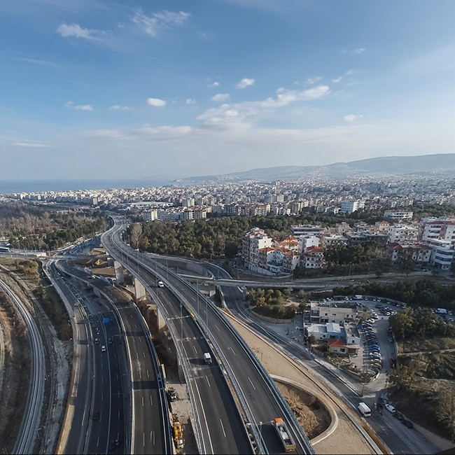
Flyover: Traffic Upgrade of Thessaloniki’s Inner Ring Road
Consortis, through its specialized surveying department, serves as a technical consultant for the landmark project "Flyover", which aims to upgrade traffic flow on Thessaloniki's Inner Ring Road. The project involves constructing an Elevated Expressway (Flyover) that will improve traffic conditions, enhance mobility, and promote urban development.
The Problem
Thessaloniki's Inner Ring Road faces significant traffic issues, including high congestion levels, delays, and accidents. The need for infrastructure upgrades with modern traffic solutions was imperative, while the expropriation of land was a critical step in the project's implementation.
The Solution
Consortis played a pivotal role in the project, providing technical consultancy services for complementary expropriations and updating cadastral data. Specifically, our services included:
Benefits
The Flyover project and Consortis's contributions deliver substantial benefits to the city of Thessaloniki:
This project is a milestone for Thessaloniki, with Consortis’ Cadastre and Land Surveying Department playing a crucial role in its successful execution, contributing to improved quality of life and urban development.
Ministry of Infrastructure and Transport
Thessaloniki
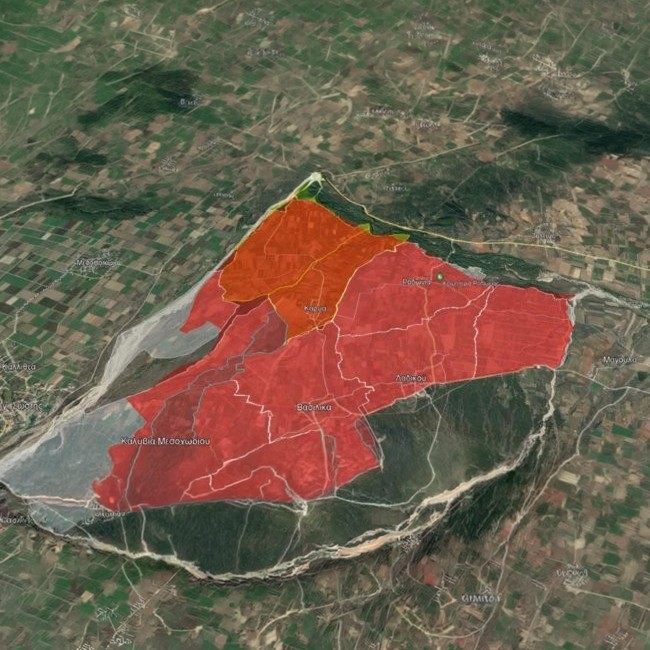
Cadastral Survey for the Creation of a National Cadastre in the Remaining Areas of the Thessaloniki Regional Unit
Consortis is participating in one of the largest and most significant cadastral projects in the Thessaloniki Regional Unit, supporting the creation of a comprehensive and modern National Cadastre. The project involves the systematic recording and documentation of property rights across 19 areas in the region, including:
Municipality of Volvi (Ag. Georgiou, Apollonia, Arethousa, Egnatia, Madytos, Rentina)
Municipality of Delta (Chalastra, Axios)
Municipality of Pylaia–Chortiatis (Chortiatis)
Municipality of Lagkadas (Assiros, Vertiskos, Kallindoia, Koroneia, Lagkadas, Lachanas, Sohos)
Municipality of Thermaikos (Epanomi)
Municipality of Thermi (Vasilika, Mikra)
Municipality of Oreokastro (Kallithea, Mygdonia)
The Problem
The absence of a fully developed and functional National Cadastre has created significant issues in property transactions, land use planning, and the development of infrastructure projects. The involved areas in the Thessaloniki Regional Unit present particular complexity due to the large number of property rights requiring precise documentation and processing.
The Solution
The Surveying and Cadastral Studies Department of Consortis employs advanced methods and specialized expertise to implement the project:
Benefits
This project provides critical advantages for local communities, administrative authorities, and the broader region:
Support for Local Development: Boosts investment activity and sustainable development through a reliable cadastral system
Upon completion, Consortis will contribute to the creation of a reliable and functional National Cadastre, enhancing security, transparency, and development within the Thessaloniki Regional Unit.
Hellenic Cadastre
Thessaloniki Regional Unit
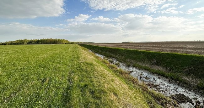
Consortis Implements a Vital Project for the Agricultural and Economic Development of Eastern Vistriza
Consortis, through its specialized surveying team, carried out a critical project for the agricultural and economic development of Eastern Vistriza. The contract involves completing all necessary tasks for the land consolidation of farmlands located within the area of the region’s irrigation project.
The Problem
The fragmented and inefficient layout of existing farmlands in Eastern Vistriza hinders agricultural development, reduces cultivation efficiency, and complicates the sustainable use of natural resources.
The Solution
The Consortis surveying team has undertaken the implementation of a comprehensive land consolidation plan, which includes:
Benefits
The land consolidation of Eastern Vistriza’s farmland provides multiple significant benefits:
Region of Central Greece
Central Greece
Scanning of Negative Aerial Photographs for the Archive of the Hellenic Cadastre
Consortis, as part of a consortium of three companies, participates in a strategically important project for the Hellenic Cadastre, providing digitization and georeferencing services for negative aerial photographs. This project aims to create a fully digitized and georeferenced database, enhancing the management and utilization of the country’s geospatial data.
The Problem
The archive contains approximately 407,000 aerial photographs in analog format, with extremely delicate material, making their management, storage, and utilization challenging and time-consuming. Converting these photographs into digital format with high precision and georeferencing them was essential for their effective use within the Hellenic Cadastre framework.
The Solution
The Surveying Department of Consortis, along with its partner companies, implemented an advanced process of digitization and georeferencing:
Benefits
Consortis’ participation in this project offers multiple benefits:
This project represents a milestone in the transition of the Hellenic Cadastre to a modern, fully digitized system, with Consortis’ Surveying Department playing a key role in its successful completion.
Hellenic Cadastre
GEOSYSTEMS HELLAS - DIGITAL EARTH
