FLOODGUARD, Greece. Cross-Border Flood Management - Evrymap.
FLOODGUARD, Greece. Cross-Border Flood Management - Evrymap.
The Floodguard Project, funded by the INTERREG VA Greece-Bulgaria 2014-2020 program, aims to strengthen collaboration between Greece and Bulgaria in managing flood risks in the cross-border river basins of the Evros, Nestos, and Strymonas rivers. This initiative focuses on developing a comprehensive action plan for flood prevention and response by leveraging advanced geospatial technologies and data analysis.
The Problem
The cross-border river basins of the Evros, Nestos, and Strymonas face increased flood risks due to climate change and the lack of integrated water monitoring and management systems. The absence of coordinated cooperation between Greece and Bulgaria complicates decision-making and delays flood prevention and mitigation efforts, putting local communities and economies at risk.
The Solution
The Floodguard Project addresses these challenges by implementing an advanced cross-border flood risk management system, centered around the EVRYMAP Web GIS platform, developed by Consortis Geospatial.
EVRYMAP Web GIS Platform
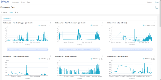
EVRYMAP is a cutting-edge web GIS platform designed to store, manage, and visualize data from telemetric water monitoring stations. These stations collect real-time data on water levels, temperature, pH, depth, and other critical indicators, feeding them into the platform for analysis and visualization.
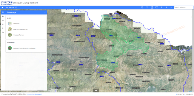
- User-Friendly Interface: Provides real-time data access through a map portal and dashboard
- Accessibility: The platform is accessible via http://floodguard.m-t.gov.gr/evrymap/map
Key Features of EVRYMAP
- Navigation Tools: Seamless map navigation with zoom and reset options.
- Address Search: Search for specific locations using city or area names.
- Identification Tool: Select objects on the map and export data in .csv or .shp formats.
- Thematic Layers: Manage and customize layers based on user needs.
- Distance and Area Measurement: Calculate distances and areas with lines or polygons.
- Coordinate Navigation: Input and display points based on coordinate systems such as HGRS87 and WGS84.
- Map Printing: Create customized maps with adjustable titles, scales, and descriptions.
Dashboard and Data Visualization
The platform’s dashboard, connected to an Apache Superset database, provides:
- Data Visualization: Graphs and charts for real-time monitoring of water quality and levels
- Timeframe Customization: Focus on specific periods and areas of interest
- Data Export: Extract data as images or .csv files for further analysis
Benefits of the Floodguard Project
By integrating these features, the Floodguard Project delivers:
- Advanced Flood Management: Enhances monitoring and analysis capabilities for timely flood prediction and mitigation
- Cross-Border Cooperation: Improves coordination between Greece and Bulgaria for disaster prevention
- Decision-Making Support: Provides reliable, real-time data for informed decisions
- Skill Development: Trains local authorities in GIS technology and geospatial data management
- Sustainable Development: Protects local communities and economies from the impacts of flooding
The Floodguard Project, through the EVRYMAP platform, establishes a modern, proactive, and technology-supported approach to flood risk management, enhancing the resilience of cross-border regions.
KEY FACTS
Decentralized Administration Macedonia – Thrace
Eastern Macedonia and Thrace


An effective, flexible, and responsive team that offered solutions and stelar expertise.
An effective, flexible, and responsive team that offered solutions and stelar expertise.