Participation of Consortis Geospatial in the FIG 2026 Congress
Consortis Geospatial participated in the XXVIII FIG Congress of the International Federation of Surveyors (Fédération Internationale des Géomètres – FIG), held in Cape Town, South Africa, May 24-29, 2026. FIG 2026 represented a milestone event for geospatial professionals worldwide, aiming to accelerate innovation in the field of surveying engineering and contribute to shaping the next era of global sustainable development. The congress brought together members of the international academic community, policymakers, industry experts, and professionals to explore how land governance, geospatial intelligence, and technological advancements can support sustainability, resilience, and equitable development beyond 2030. FIG 2026 is expected to act as a catalyst, for bold ideas and strategic initiatives that will help secure a sustainable future for generations to come.
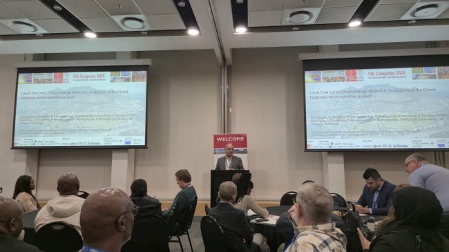
Consortis Geospatial was represented at the congress by the company’s Chief Executive Officer, Mr. Georgios Tsakoumis, and the company’s Technical Director and Scientific Advisor on Earth Observation, Dr. Georgios Vergos. During the event, the company presented, through both oral and poster talks, the outcomes of two recent projects focusing on innovative approaches to the analysis, visualization and interpretation of surveying and geospatial data.
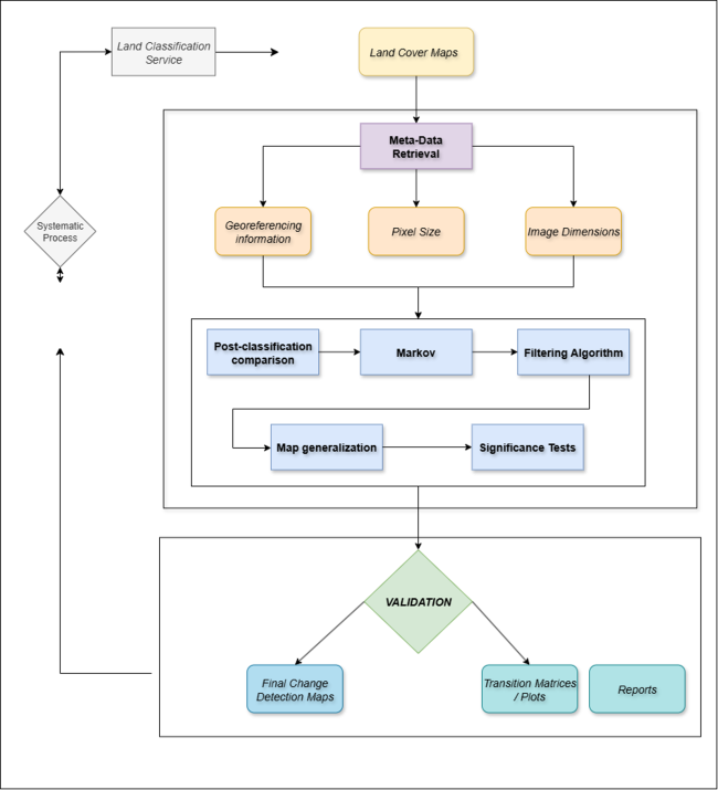
As part of the joint FIG–ISPRS session TS03E: GeoAI and Geo-analytics for Sustainable Land and Inclusive Places, Consortis gave an oral presentation entitled “Land Use Land Cover Change Detection in Support of the Greek National Micro-satellite Project”. The study summarized the results acquired in the frame of the Sat4GAIA project – Axis 3: Land Monitoring Service of the Greek National Satellite Space Programme (ESA / “Greece 2.0”). The proposed methodology is based on Land Use/Land Cover (LULC) change detection across 22 classes using a Post-Classification Comparison approach applied to annual national LULC maps. The methodology incorporates Markov Chain modelling of transition probabilities and slope integration derived from the Copernicus 10 m DEM, followed by cartographic generalization and dual validation procedures, including both internal statistical validation and external photointerpretation-based assessment. The results indicate annual changes ranging between 2–3%, ~1.5% of which are attributed to wildfires, while achieving an overall external accuracy exceeding 80%. Furthermore, no statistically significant differences were identified between filtered and unfiltered maps (F-test, p > 0.05). These findings demonstrated the operational maturity of the methodology to support environmental monitoring, spatial planning, and decision-making within the framework of the Greek micro-satellite programme.
Within session TS01I, Consortis Geospatial had a poster presentation entitled “Managing and Monitoring Coastal Erosion in Greece with Satellite and In-situ EO Data Assimilation”. The study focuses on the development of an integrated Coastal Erosion Observatory for the Region of Central Macedonia, aiming to support the transition from reactive emergency response to proactive disaster risk reduction.
The methodological framework combines multi-sensor satellite data assimilation from Sentinel-1 (vertical deformation rates derived through InSAR), Sentinel-2 (NDVI and land use data), Sentinel-3 (sea-level anomalies and sea surface temperature), and Landsat imagery (long-term shoreline evolution), together with high-resolution, heterogenous, in-situ measurements. These include UAV/GNSS surveys at 1:500 scale, bathymetric surveys using echo sounding, telemetry buoy monitoring wave and meteorological parameters, and mapping of Posidonia oceanica habitats.
The analysis was further enhanced through the construction of a 28-year sea-level time series (mean epoch 2007.0) derived from multi-satellite altimetry missions, including Jason-1/2/3, Sentinel-3a/3b, CryoSat, and SARAL/AltiKa. After applying EOF analysis to remove seasonality and long-term trends, and through the generation of a quasi-static Sea Level Anomaly (SLA) field for the Mediterranean basin, the work quantified sea-level pressure on coastal areas.
Advanced numerical simulations and “bathtub” modelling approaches were subsequently applied for two future scenarios (2000–2049 and 2050–2099) across three pilot areas, namely Fourka, Asprovalta, and Katerini, all under Category 5 storm scenarios. The results are integrated into a Web-GIS platform that visualizes coastal vulnerability and supports regional policy-making, highlighting the observatory as an operational tool for coastal spatial planning and climate change adaptation.